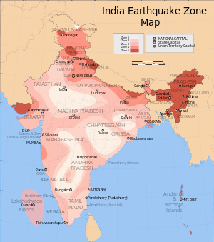
Earthquake zones of India
The Indian subcontinent has a history of devastating earthquakes. The major reason for the high frequency and intensity of the earthquakes is that the Indian plate is driving into Asia at a rate of approximately 47 mm/year.[1]Geographical statistics of India show that almost 54% of the land is vulnerable to earthquakes. A World Bank and United Nations report shows estimates that around 200 million city dwellers in India will be exposed to storms and earthquakes by 2050.[2] The latest version of seismic zoning map of India given in the earthquake resistant design code of India [IS 1893 (Part 1) 2002] assigns four levels of seismicity for India in terms of zone factors. In other words, the earthquake zoning map of India divides India into 4 seismic zones (Zone 2, 3, 4 and 5) unlike its previous version, which consisted of five or six zones for the country. According to the present zoning map, Zone 5 expects the highest level of seismicity whereas Zone 2 is associated with the lowest level of seismicity.
Contents
[hide]National Center for Seismology[edit]
National Center for Seismology, Ministry of Earth Sciences is nodal agency of Government of India dealing with various activities in the field of seismology and allied disciplines. The major activities currently being pursued by the National Center for Seismology include, a) earthquake monitoring on 24X7 basis, including real time seismic monitoring for early warning of tsunamis, b) Operation and maintenance of national seismological network and local networks c) Seismological data centre and information services, d) Seismic hazard and risk related studies e) Field studies for aftershock / swarm monitoring, site response studies f) earthquake processes and modelling, etc.[3] The MSK (Medvedev-Sponheuer-Karnik) intensity broadly associated with the various seismic zones is VI (or less), VII, VIII and IX (and above) for Zones 2, 3, 4 and 5, respectively, corresponding to Maximum Considered Earthquake (MCE). The IS code follows a dual design philosophy: (a) under low probability or extreme earthquake events (MCE) the structure damage should not result in total collapse, and (b) under more frequently occurring earthquake events, the structure should suffer only minor or moderate structural damage. The specifications given in the design code (IS 1893: 2002) are not based on detailed assessment of maximum ground acceleration in each zone using a deterministic or probabilistic approach. Instead, each zone factor represents the effective period peak ground accelerations that may be generated during the maximum considered earthquake ground motion in that zone.
Each zone indicates the effects of an earthquake at a particular place based on the observations of the affected areas and can also be described using a descriptive scale like Modified Mercalli intensity scale[4] or the Medvedev–Sponheuer–Karnik scale.[5]


Comments
Post a Comment